But a great session does not automatically make for a great presentation to others. bCisive contains a powerful tool -- PowerPoint export -- to help construct visually compelling presentations, but to get the most out of it, you need to know how to break a big map into a well-organized story.
The problem: You had to be there!
The result of a good session typically yields a big map, and if this is presented as it stands to someone who wasn't part of the original session, rather than getting buy-in more typical responses are incomprehension or distancing.
Breaking a map into several slides
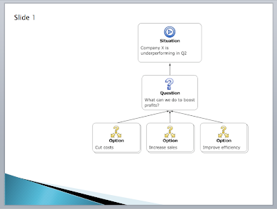
First, we create an overview slide by hiding the branches below the top couple of levels, and taking a slide.
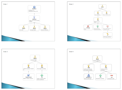
Next, we show the branches again and take slides of each one separately. Export to PowerPoint for (in this case) a four-slide presentation:
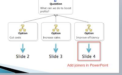
Now, we simply add joiners in PowerPoint to indicate how the parts of the map connect.
The result is a clear and easy-to-follow presentation of the separate parts of the argument, resolution or proposal.
We've found that this process works very well for us, but it may not be suitable for some styles of presentation. We'd love to hear about other ways that also work well, especially with an instructive example. Please let us know!
The solution: Tell a story
The basic idea is to break down the map, which in its original form shows everything all at once, into a linear narrative: a story.
Using the output-to-PowerPoint feature, you can export your map straight to PowerPoint where you can add logos and text for a great visual summary. To create your story, break your map into bite-size chunks, and organize them in a way that will make it easy for your audience to follow. Here's how we do it:
- Start with an overview
- Drill down into the good bits (discard the bits you don't need)
- Show the links

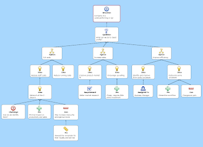
An example of a big map (click for full size)
Breaking a map into several slides
First, we create an overview slide by hiding the branches below the top couple of levels, and taking a slide.

Next, we show the branches again and take slides of each one separately. Export to PowerPoint for (in this case) a four-slide presentation:

Now, we simply add joiners in PowerPoint to indicate how the parts of the map connect.

The result is a clear and easy-to-follow presentation of the separate parts of the argument, resolution or proposal.
Expert tips:
- For deep maps, the drill-down may need to be broken across multiple slides, repeating the same trick
- In bCisive desktop you can add headers and footers from within bCisive, and also choose to export some slides in a dot point format; these features can be expected to arrive in due course in bCisive Online
- A conclusion slide at the end can remind the audience of the original overview, ideally with a little visual variation
We've found that this process works very well for us, but it may not be suitable for some styles of presentation. We'd love to hear about other ways that also work well, especially with an instructive example. Please let us know!
We think it would be great if a map sliced up into slides and exported from bCisive Online had any necessary joiners added automatically. Something to look forward to.


No comments:
Post a Comment